Last April when Novel influenza A (H1N1) – swine flu – emerged onto the world stage, students in Texas watched with concern. Would their education, sports and social activities be affected? Some districts halted student travel. Others cancelled classes for a period of weeks. The Texas Education Agency made recommendations to reschedule or cancel area and state-level sports. No wonder that with prom, spring concerts, and graduation ceremonies approaching, students waited nervously as local school districts made cautious decisions.
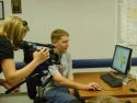
But not everyone waited. Lubbock Independent School District teacher Penny Carpenter saw a unique opportunity for her students to learn from this real-world topic. Carpenter teaches a GIS (Geographic Information Systems) course to students at the Byron Martin Advanced Technology Center. Knowing the important role GIS tools would play in monitoring the flu’s pandemic potential, she devised a special project for her students: map the spread of swine flu in Texas counties.
This was not the first real-life project for the GPS/GIS class, according to Carpenter. “We have explored forest fire activity in Southern California, tracked the path and investigated the aftermath of Hurricane Ike, analyzed the terrain implications of adventurer pilot Steve Fossett's crash site, and even toured the path around a racetrack in Singapore."
The swine flu project captured the students’ attention. Although maps of countries and other states with confirmed flu cases were available, there was no map detailing the confirmed cases in Texas. For their raw data, the students used the Texas Department of Health’s website, which posted confirmed cases by county and provided daily updates.
Because the outbreak originated in Mexico, the class began by looking to the border towns for reported infections. They created a list of Texas counties in a spreadsheet and entered the data of confirmed cases. Next, they used ArcMap to create a base map of Texas counties. By matching county names, they joined the map’s attribute table to the spreadsheet data. Finally, after discussing appropriate breaks for the data range, the students mapped numbers of confirmed cases using graduated colors.
Carpenter’s course - Geographic Information Systems and Global Positioning Systems (GIS/GPS) - is an innovation she proposed and developed herself, with the approval of Texas Education Agency. There is no textbook, but instead industry-standard software, similar to what might be used in the workplace. ArcMap is a component of ArcGis, desktop GIS software. ArcGis was instrumental in the search and recovery effort of the space shuttle Columbia, and also provided spatial data used in reconstruction of the craft for the investigation afterwards.
Once the maps were created, the students began analyzing them. They discovered the darkest colors, representing the highest number of confirmed cases, appeared not in the border counties – as one might guess – but instead in the heavily populated areas. Was it possible that common features of these areas explained the flu’s spread? To answer that question, students added a layer of roadways and airports to the map for comparison. Although each major area had a large airport, all areas were also connected with major highways. The young scientists theorized that travel by car was most likely to explain the virus’ spread in Texas.
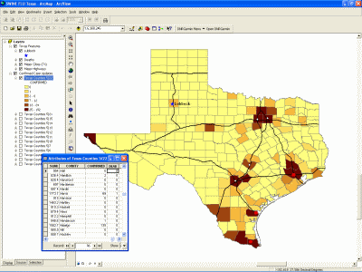
Over the next several days, the students monitored the data and watched the flu spread along the roadways. Confirmed cases colored counties on the map moving west on Interstate 20, the major highway that connects Lubbock to the rest of the state (via Highway 84). On the last day of school, the first confirmed case for Lubbock County was announced. The local television station broke the story and featured the work of Carpenter’s students. Their GIS skills created a indelible image that helped Texans better understand the progression of the swine flu.
GIS/GPS is one of many skill-based or Career and Technology Education courses offered at the Byron Martin Advanced Technology Center. Courses are open to all students from the four high schools within the Lubbock Independent School District. These weighted credit electives require no special application process, and many allow students to earn Tech Prep, dual college credit, or industry-recognized certifications.
“I’m just in awe that I can build the maps to help other people understand the data and how it affects them,” explains senior Tyler Funk. Funk will begin college in the fall, and is contemplating areas of study that will develop his ability to construct datasets and analyze them through graphical representation.
Student Monica Wolfe was fascinated by her recent research into GPS tracking of whale sharks off the coast of India. "I get to learn stuff about things that interest me in GIS, and I think that's why I love it so much,” she said. “GIS is relevant, upcoming, and beneficial to everything."
GIS is used in business, defense and intelligence, education, government, health and human services, natural resources, public safety, transportation, and utilities and communication.
Penny Carpenter has no doubt that she teaches more than building maps. “When students can see the data on a map, they begin to analyze, and this promotes higher-level thinking skills,” she said. “I believe students want school to be exciting, challenging, and meaningful. Creating a learning environment that uses technology the same way professionals do helps the students find pathways for career interests."
